Lesson Learned

This morning Rob came home after giving a final exam and said, “You want to go for a bike ride?”
It's December. The riding season is over. But there's no snow to pull me outside on my skis, and a pulled muscle keeps me from running. I haven’t done anything fun outside in days. Maybe that’s why I’ve been in a funk. Or it could be because we’re approaching the shortest day of the year or because my son has just left home for good and won’t be back for Christmas.
I looked out the window. I could hear the wind even as I saw the trees swaying back and forth. But the sky was blue. I checked the thermometer - 48 degrees. Forty is the cutoff.
“Sure. Let’s go around the reservoir.”
That’s our shortest loop - past a horse farm, then an old barn and farmhouse before turning up a tree-lined residential road and on through a wetland. Past more houses and through some woods then onto a stretch of highway and along the reservoir, and back onto country roads before finally completing the loop. It’s one of the first rides we do in the spring when we’re just getting back on our bikes, the buds starting to show on the trees and daffodils blooming alongside the road. In the summer it’s our quick gotta-get-out-but-don’t-have-much-time ride and I’ll admire the gardens we pass, all much prettier than mine. And in the fall, we track the progress of the leaves changing, some individual trees particularly spectacular year after year, and we marvel at the trees' vibrant reflections on the reservoir.
Today, there was little to admire. Brown leaves covered the ground and the trees were a drab gray. Even so, after a half mile I felt my doldrums lift.  Being out under a clear blue sky, riding past fields and open spaces, feeling the cold wind on my face, and pushing myself physically, I felt invigorated. 
There is nothing remarkable about an 11-mile ride in December. But today, it was exactly that.

Thank you, Rob, for getting me out.

Day Tripping in New Hampshire (1) - Peterborough Loop

On every ride the same 3 trees
greet me as I turn into my street.
I decided to try my hand at
painting one of them.
I call this "Local Color."
The same thing happens every year. The green forests slowly turn into a brilliant pallette of reds, yellows, and oranges bringing on a show that pulls me outside on my bike to marvel at the splendor as it unfolds along each of my favorite local rides. I ride along ridges with the vibrant colors softening on the hills as they blend into the horizon, around lakes where the pageant is doubled by the water’s reflection, and alongside green pastures, the changing trees a varicolored backdrop. Every ride takes me down roads embraced by the New Hampshire forests that, cut down by early settlers, have reclaimed their birthright to stand in crowds behind old stone walls along the roadside, forming a canopy overhead.
During the too few weeks of autumn, the leaves, having given up their summer green, can only hang on for so long. As they fall around me, I feel a part the seasonal transformation.
Strong wind gusts last week brought down the curtain on the final act of this Fall Foliage Display.  By Saturday, as Rob and I ride our bicycles through the Monadnock region in southern New Hampshire, there are few colors left and the only thing falling is a rotted old birch tree. I catch the movement out of my peripheral vision, turn to see the tree hit the ground, hear the crash, and evaluate its thickness as I ride by. It must have been pretty rotten and probably soft but how much damage would it have done if it had landed on me? Would it have killed me or just landed me in a wheel chair for the rest of my life? It fell in the woods beside the road but, even so, I look ahead and try to assess the chances of a tree crashing down on me.
I know people who are so worried about the dangers awaiting bicyclists who venture out onto the roadways that they won’t even consider getting on a bicycle. I acknowledge the risks and do my best to mitigate them. I wear a helmet, watch for cars pulling out onto the road, use hand signals, and ride at least three feet from parked cars. (A bicyclist died recently after crashing into a car door that opened as he was riding by. These things happen.) But this was a new hazard I hadn’t yet considered – getting wiped out by a falling tree. What a bummer that would be.

We have embarked on a 36-mile ride that starts and ends in Peterborough. The ride is described in Best Bike Rides New England, by Paul Thomas. We have the 4th edition of the book, published in 1998, a tad bit out of date and it appears not to have been updated since, is in fact out of print. You can still get a copy of the book – new or used - through Amazon. (Used for a penny; with shipping it’s $4). If you are going to do any riding in New England, I highly recommend it. We’ve been very happy with the rides we’ve done.

Like a politician who says only enough to avoid speaking the truth, the author begins the ride description with, “About the only attraction this part of New England doesn’t offer cyclists is long steep hills.” Perhaps. We start out slow, uphill, level off, then more uphill. Not long and steep, just long and gradual, so 
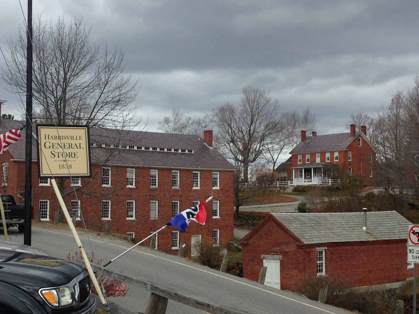
that, when we arrive in Harrisville after ten miles, we’ve only averaged around 9.8 mph. And the hill into Harrsville isn’t long and steep either, just short and steep. A short, steep hill and at the top is an old general store with a picturesque porch overlooking the old textile mill and surrounding brick buildings of this quaint New England town, founded in 1774 with the construction of a combination sawmill and gristmill. I pull into the parking lot and wait for Rob.
The Harrisville General Store opened in 1838 and is now owned by Historic Harrisville, Inc., a non-profit dedicated to the preservation of Harrisville’s mill town buildings.
“How about we take a break?” I ask.
“Sure,” he says, always agreeable.
Warm air hits us when we go inside. People are seated at small tables by the front window. There are various food and gift items for sale, a deli case and baked goods on the counter.
Many small-town general stores in New England have been transforming themselves into coffee and sandwich shops. Which brings me, proud foodie that I am, no end of happiness.
Rob thinks he’ll have a muffin until I point out the braided cinnamon bread sitting on top of the deli case.
“Let’s eat in here,” he says.
“No, I want to sit outside.” I am not as agreeable as Rob. But at least the woman at the cash register backs me up. “It’s too hot in here,” she says.

Early November in New England can be anything. Yesterday Global Warming brought us a summer day, but today is more seasonal. At 9:30, when we started out, it was warm enough to ride in shorts and a light jacket, but I decided to add an extra layer, a lightweight long-sleeved shirt under a short-sleeved tech shirt and haven’t regretted it. It’s an overall gray day, but still warm enough to sit outside on the porch of the general store and enjoy a cinnamon roll along with the tea and oranges we packed.

Back on our bikes, it still feels like we’re gaining some altitude, not tearing through the miles. Time to marvel at the forest streams, lakes, and farms that we pass by. And then there are these cows that are the oddest cows either of us has ever seen. They are black with one big white stripe wrapped around their middle. I’m sorry, but I didn’t stop to take a picture.
We come to the town of Nelson, which isn’t much of a town, really, kind of like our town, Madbury, with a town green, a pile of mailboxes, town hall and a small library. Nelson is known in the New England folk music community for its Monday night contradances, a weekly tradition going back many years. We cycle on through and get rewarded for all our climbing with a lovely long downhill ride.
The amount of traffic on this main
east-west highway gives you an idea
of how quiet the countryside is in
this little corner of New Hampshire.
No big box stores on this
part of Rte. 9
We ride alongside a lake and by now I’ve lost count of how many lakes we’ve passed, docks pulled out, sitting randomly along the shore. We turn onto Rte. 9, a major two-lane highway that runs east-west through southwestern New Hampshire. A roomy shoulder and light traffic make three miles fly by and then we’re on Rte. 123, a quieter road, for nine well-earned downhill miles into Hancock.  Quoting Wikipedia here, “Almost every building on Main Street in downtown Hancock is listed on the National Register of Historic Places as part of the Hancock Village Historic District.” Old brick buildings, a town green, tree-lined main street, yes, it is as quaint as it sounds.
Sitting proudly on Main Street is the Hancock Inn. And rounding out the business district across the street, sitting side by side, are a general store and the Fiddleheads Cafe, just in time for lunch.  Inside Fiddleheads is bustling with diners. We both order an Indian chicken soup at the counter, where my will power is sorely tested with the desserts all packaged and ready to go home with me. But, with a cinnamon roll behind me and home-baked cookies waiting at our bed and breakfast, I steadfastly resist any temptation and stick with just the soup.
The temperature has been dropping and we both put on warmer clothes for the last seven miles back to Peterborough.  And these miles, too, go by quickly as we continue to be rewarded for our early morning climbing and finish our ride on a quiet country road.
We’re back in Peterborough before 2:00. On our arrival in town, I count my fifth Bernie sign of the ride.

Living in New Hampshire, it feels like we are always in the midst of a presidential election season. No sooner has one president taken office then here comes the next batch of contenders, testing the waters, working on name recognition. Bernie Sanders has been visiting New Hampshire for a while, and is pretty well known, coming from right next door in Vermont. I won't get into his politics here, because this isn't a political blog. But what I want to say that what struck me was that there were no other political signs, Republican or Democrat, to be seen along the way. And usually, while the Seacoast region of New Hampshire, where we live, tends to be more liberal than the rest of the state, I was just a bit surprised by this popping up of Bernie signs, with no sign of support for anyone else. It probably means nothing, but I just thought I throw it in. Something to chew on.
We’ve planned to spend the weekend here, time to enjoy browsing in some art galleries, go out to dinner, do some contra dancing, maybe some hiking in the morning. The Monadnock area of New Hampshire is steeped in natural beauty and traditional New England culture, well worth a visit.
Here are a few suggestions:
Stay at the Little River Bed and Breakfast. Tea, freshly baked cookies and other treats greet you upon arrival and you’ll wake up to home-baked breads and a hot breakfast with fresh fruit.
Dine at Marzano's Trattoria. But don’t wait too long. Their 5-year lease is about to run out and the owners haven’t yet decided if they’ll renew.

Lunch at  Harlow's Pub. A pub with good food – I had a delicious spicy chicken and rice soup - and outdoor seating.

Bicycling Maine (6) - Where's the Campground?

Day 3: Sunday, May 24, 2015
Yarmouth to Bailey’s Island:  38 miles (averaging 10.72 mph)

Sometimes, when the riding gets tough – my butt so sore it feels like I’m sitting on top of a flag pole, the legs tell me they’re done for the day and I tell them we have at least 20 more miles, and here comes another hill to climb while traffic is roaring by at 60 mph and I’m hanging onto a narrow shoulder pockmarked with pot holes  – I wonder how I can think this is fun. Then, the next day, we meander down scenic back roads with a light breeze and the temperature in the seventies, the views opening up on pristine bays and rock-strewn coasts, and I feel sorry for all the poor fools who think that riding a bicycle is work.
And today is just that day. We get started shortly after noon and ride a bit on U.S. Route 1, where the highway runs quietly for a stretch without the bother of coastal towns and their restaurants, strip malls and tacky tourist traps.  Then we’re off on local roads that loosely follow the coastline. We stop for a late lunch at a boat launch, overlooking a peaceful bay. As we eat we watch the sky darken and rain begins to fall and we put rain covers on our panniers.
We stop for lunch at Wharton Point boat launch.

But it doesn’t rain and the riding is fine, even as we start getting into some hills. Then we're starting our tour of Maine's peninsulas and a few of its many islands. (Maine has over 3000 islands – 3166 if you believe Wikipedia. But, according to waterfrontpropertiesofmaine.com only 41 of these are inhabited.)
           We ride across causeways and bridges and by now we have likely arrived on Orr’s Island and should be getting to our campground. Which we can’t seem to find. We pass cemeteries and ponds and woods and driveways and dirt roads and a sign for a motel, but nothing about a campground.

A garden catches our attention and alongside is a café. Inside, Rob waits patiently in line, then asks the woman behind the counter if she knows anything about the campground. Is it open? 
“Oh, yes. It should be open. Head back north, past the cemetery and when you can see a pond on your right look for the dirt road on the left with a wagon wheel at the end of it.”
We ride back a mile or so and find the cemetery and there’s the pond but we still haven’t seen any sign for a campground. We turn around and try again, stop along the side of the road and then we do see a dirt road with a wagon wheel. But there's no sign. We ride down the road anyway, and there's the campground in a gorgeous spot overlooking the water which would be a lovely place to spend the night. But not for us. There's a sign that  welcomes seasonal RVs, but no tents because there's no bath house. So that’s that.
I take the turn off the dirt road onto the highway just a tad too sharp and don't unclip out of my pedals in time. I hit the dirt, indignity added to disappointment.
At this point, anyone else would pull out his or her smart phone and ask Siri where’s the nearest campground, or motel or B&B. But all we have is a dumb phone that is next to useless once we’re beyond any major populated area.
So instead of asking Siri, I ask Rob, “Did you see that sign for a motel? Let’s check it out.”
We follow the arrows into a residential neighborhood and bicycle around in what feels like suburbia and an unlikely place for a motel. I go up one road and Rob another and when a car stops at an intersection Rob talks to the driver, who tells him the motel was turned into condos a few years ago. I guess nobody cares about updating those blue highway signs.
No campground, no motel.
We stop back at the café and this old guy sitting at a table drinking coffee says there are several motels down the road. It’s Memorial Day weekend. What are the chances of a room being available?
We cross the bridge to Bailey Island and straight ahead, on the other side, is a motel. 
Straight ahead to the Bailey Island Motel
Inside the office, I ask the woman behind the desk about a room.
“I can give you one for $125.”
“That’s a little more than we were hoping to spend. Are you the only place around?”
“There’s another motel down the road. It’s cheaper but we have a better view.” 
“What are the chances of you renting out your last room while we go check it out?”
“We have plenty of rooms left.” Evidently the tourist season hasn't started. “I’ll tell you what. I can let you have a room for $100.”
Outside, Rob and I discuss our options. I can totally get into parking myself in one of the Adirondack chairs overlooking the harbor, and Rob's got his eye on the restaurant next door.
The budget will take a hit tonight.


[The Bailey Island Motel turns out t be a real gem. Check out this newspaper article which describes it perfectly. You’ll want to visit, for sure.]

Bicycling Maine (5) - Planning a No Itinerary Trip


Sunday Morning, May 24, 2015
Even though we like to travel with no set agenda, we still try to formulate a plan for each day, taking into consideration how far we feel like riding and where we might be able to spend the night. Because at the end of the day, it’s nice to be able to clean up, have something to eat, and have a safe and somewhat comfortable place to sleep. (As much as I enjoy winging it when I travel, I have so far managed to avoid having to throw my sleeping bag down by the side of the road.) Even so, any plans we start the day with are subject to change at a moment’s notice, because you never know what adventure lies ahead.
Here’s an example. In 1989 we were riding for two weeks in Nova Scotia. Our goal each night was to stay in either a provincial or national park campground because they tend to be so much nicer and cheaper than private ones.  This particular day, the closest provincial campground was only 15 miles away and the next one too far, so we decided we'd have to make a private campground our destination and planned our route for the day accordingly.

That morning the riding was both fun and stunningly beautiful – rolling hills with panoramic views of green valleys and farms. When we stopped for lunch and looked over the map, we discovered that we were on a scenic route that looped back to the main road we had started out on. We decided to stick with it and finished the day camping at a provincial campground after all - the one just 15 miles from our starting point.
Bicycling Nova Scotia in 1989
So here it is, the third day of a two-week trip meandering along the Maine Coast with a hopeful destination of the Canadian border before turning around and bicycling home to Madbury, New Hampshire. What's the plan going to be today? Even though we spent Friday night at a hotel (celebrating our anniversary) and last night with our friends Sally and Steve, we have brought along a full complement of camping gear. I’ll be damned if I’m going to carry all this gear and not use it. We’re camping tonight.
We rode 45 miles on Friday and 77 yesterday. How far today?
In 1980 I cycled solo from Boulder to San Francisco, by way of the Canadian Rockies. I spent eight weeks on the road, clocking 3000 miles when I rode over the Golden Gate Bridge. Some days I rode a hundred miles; if I needed a rest day I’d ride fifteen. Occasionally I’d take a day off to hike. In the end, my average came out to 55 miles a day.
But the image of some beautiful gardens I passed in Victoria, on Vancouver Island, stuck in my head. I didn’t stop because, at the time, I was just tired of being alone and thought there was no point in stopping when I had no one to share it with. I thought about that - and other days when I wanted to rest but had no one to spend the day with – when I looked back on my trip and decided that, on any future trip with a friend, 50 miles a day might be about right.
And that’s pretty much what Rob and I have done. On that trip in Nova Scotia, with no plans and much spontaneity, we had days when we rode over 90 miles and days when we didn’t ride at all. After 13 days, we'd ridden 650 miles - exactly 50 miles a day.
So with 122 miles behind us, if we are loosely aiming for a daily average of 50 miles (we haven’t yet made an adjustment for our advanced ages), we can take it a little easy today.
Sally makes blueberry pancakes and we sit around the breakfast table enjoying our coffee and tea and catching up on each others’ lives and no one is in any hurry to get moving on the day.
We talk about our problem of getting through Portland without a detailed map.  Steve suggests we get the DeLorme Road Atlas of Maine (delorme.com/mapstore/) . They make one for every state. “The company is right here in Yarmouth,” he says. “You can pick one up at the grocery store.” 
He shows us his copy. The state is cut into grids with detailed maps – showing local roads - of every section, and symbols for every campground and state park. It’s perfect. Except it’s unwieldy and heavy and we won’t need the whole thing.
I ask Steve, “How about we pay you for your copy? Then we can cut it up and take what we need and you can buy a new one.”
Now that we have a more detailed road map, we realize the challenge of actually riding the coast of Maine. So many peninsulas, little ones, big ones, you ride to the end of one – then what? You back track and head to the next one. Clearly we can’t get to all of them. Not if we are even going to have a prayer of making it all the way to Canada. So, we pick and choose.  We look for a campground about 40 miles away and discover a route that takes us partway down one peninsula, crosses over to another, and ends up at a campground - there's the little symbol - on Orrs Island.
The map doesn’t show mileage, so we do it the old-fashioned way. I take a scrap of paper and with the legend I measure two miles on the edge. Then I use it to roughly trace the route we’ve chosen and come up with 40 miles. I hand the paper and map to Rob. “Here. See what you get.”
Rob say, “I get 40 miles.”
Perfect.
Steve warns us that north of Portland we’ll be hitting a lot of hills. But we don’t really give it any thought, having ridden in Vermont, New Hampshire, California, and Colorado. We know hills.

Maybe.